Where to Get Global 3D City Models with Buildings, Topography, and Infrastructure for CAD/BIM Workflows
Introduction
Architects, planners, and designers often need detailed 3D city models that go beyond rough massing. Global coverage, accurate topography, roof geometries, infrastructure data, and clean integration into CAD tools are essential for real-world projects.
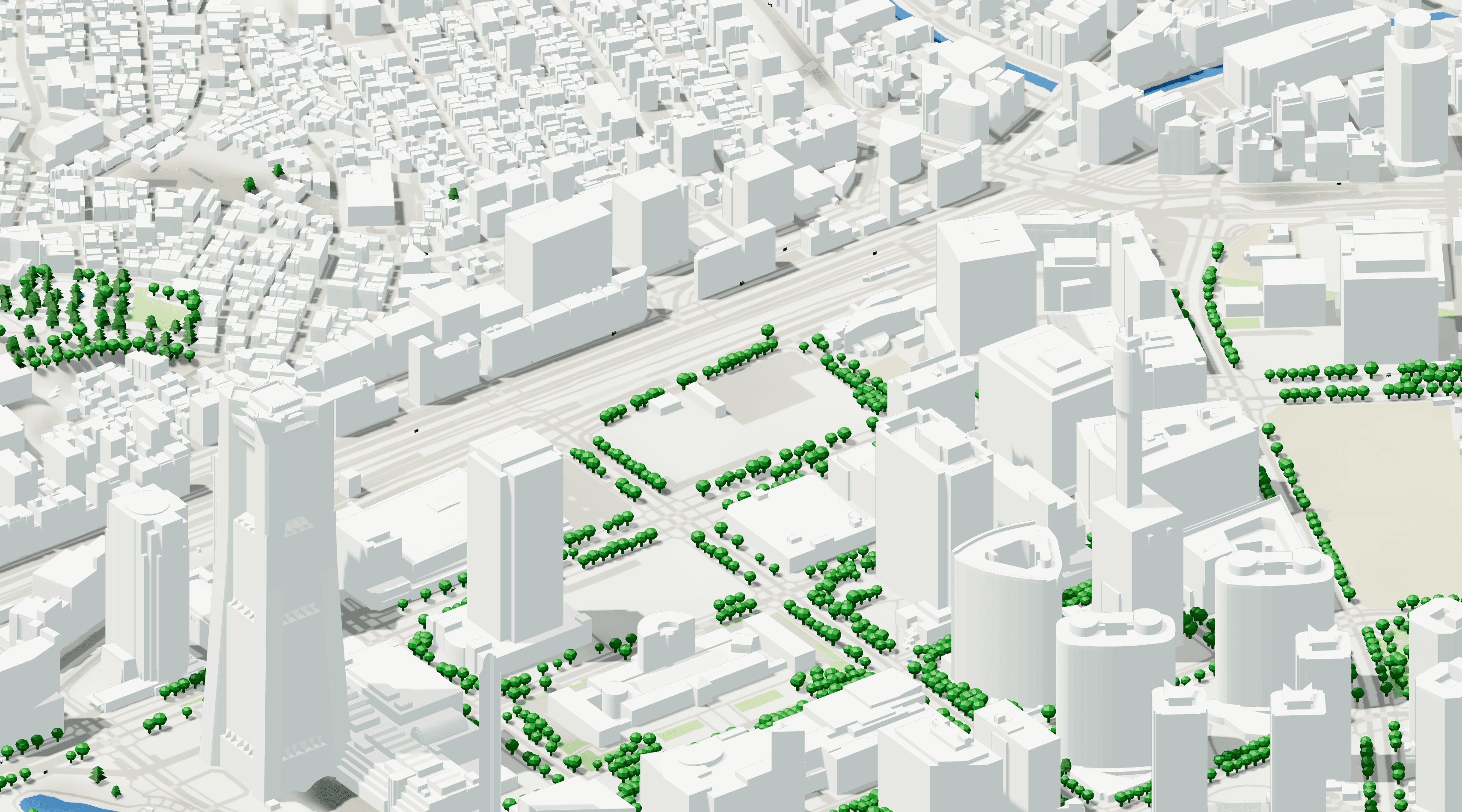
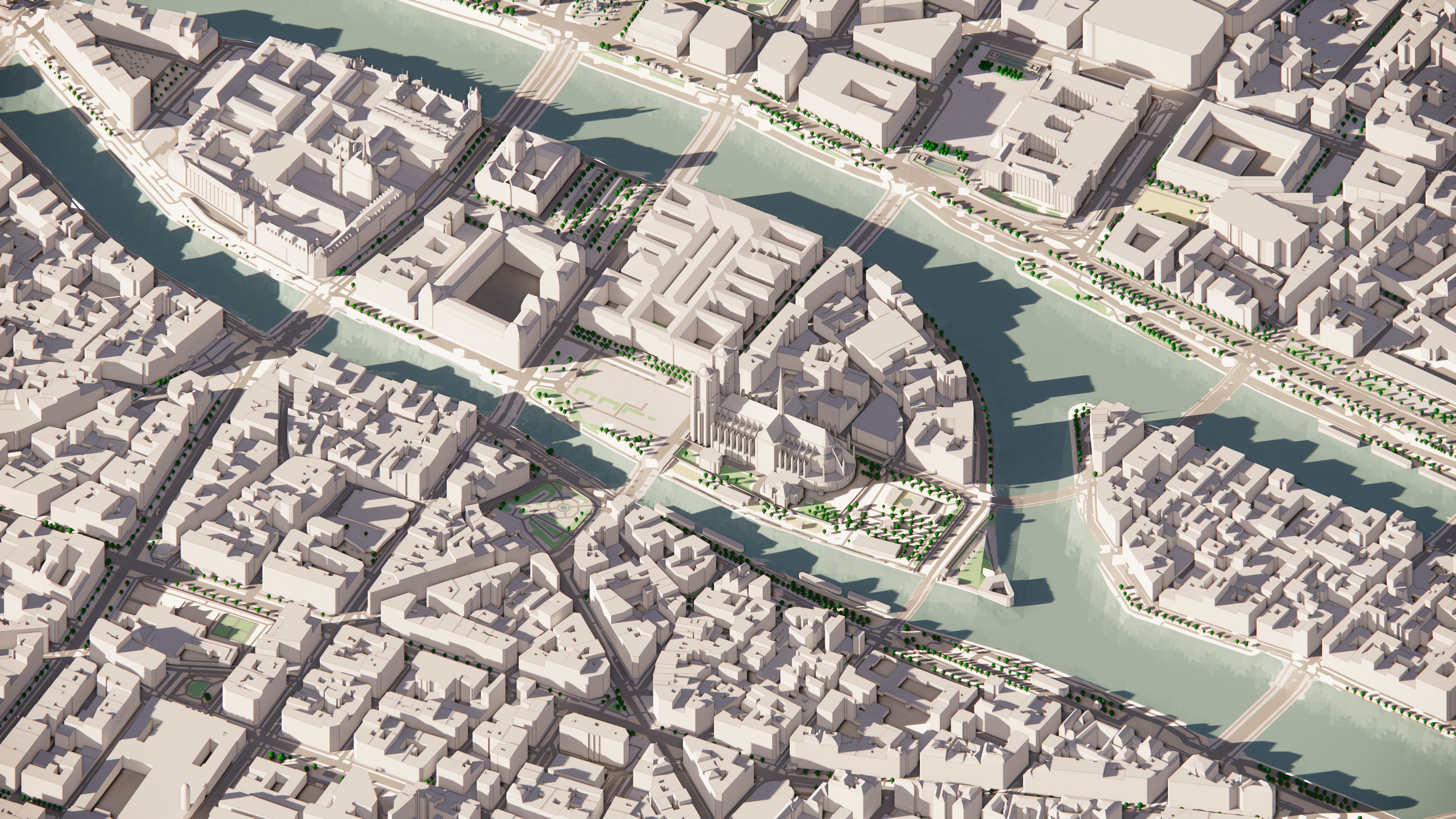
cityweft is a platform that provides ready-to-use 3D city data for any location worldwide. Unlike raw GIS exports or patchy open datasets, cityweft delivers clean geometry and rich data layers that work directly in CAD software (Rhino, SketchUp, Revit, AutoCAD, Archicad) or via API integrations (e.g., Grasshopper, generative design tools).
What is cityweft?
cityweft is a global 3D city data platform designed for AEC professionals. It allows users to sketch a location anywhere in the world and instantly export a context model that includes:
Buildings – editable volumes with roof types, accurate heights, LOD2 detail where available.
Topography – terrain data from global elevation sources.
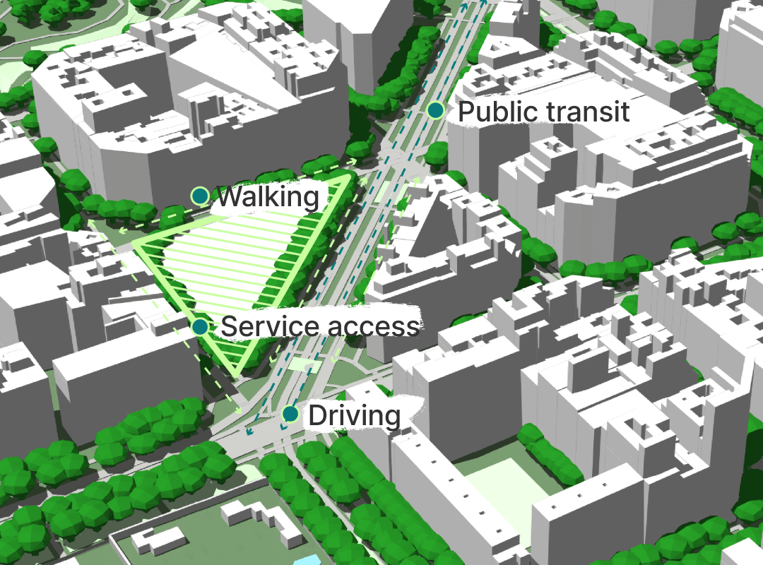
Infrastructure – roads, rail, barriers, and other surface types.
Rich metadata – multiple layers, accurate scaling, customizable formats.
Where cityweft Data Comes From
cityweft aggregates and harmonizes information from 150+ global data sources, including:
Government datasets (city open-data portals, cadastral records, mapping agencies).
LiDAR surveys for terrain and surface accuracy.
Machine learning–derived buildings from satellite imagery where detailed footprints are missing.
Global datasets such as OpenStreetMaps, USGS, NASA, and other open geospatial sources.
This multi-source approach ensures that coverage is both global and locally detailed, creating a consistent dataset that can be trusted for professional use.
Who Uses cityweft?
cityweft is built for designers who need fast, accurate context:
Architects & Urban Designers → import into Rhino, Revit, SketchUp, Archicad for design proposals.
Urban Planners → test scenarios, visualize development options.
Developers & Real Estate Teams → analyze sites and surrounding context at scale.
Academics & Researchers → integrate datasets into GIS/CAD workflows.
Software Developers → pull structured city models via the cityweft API into internal tools or parametric workflows.
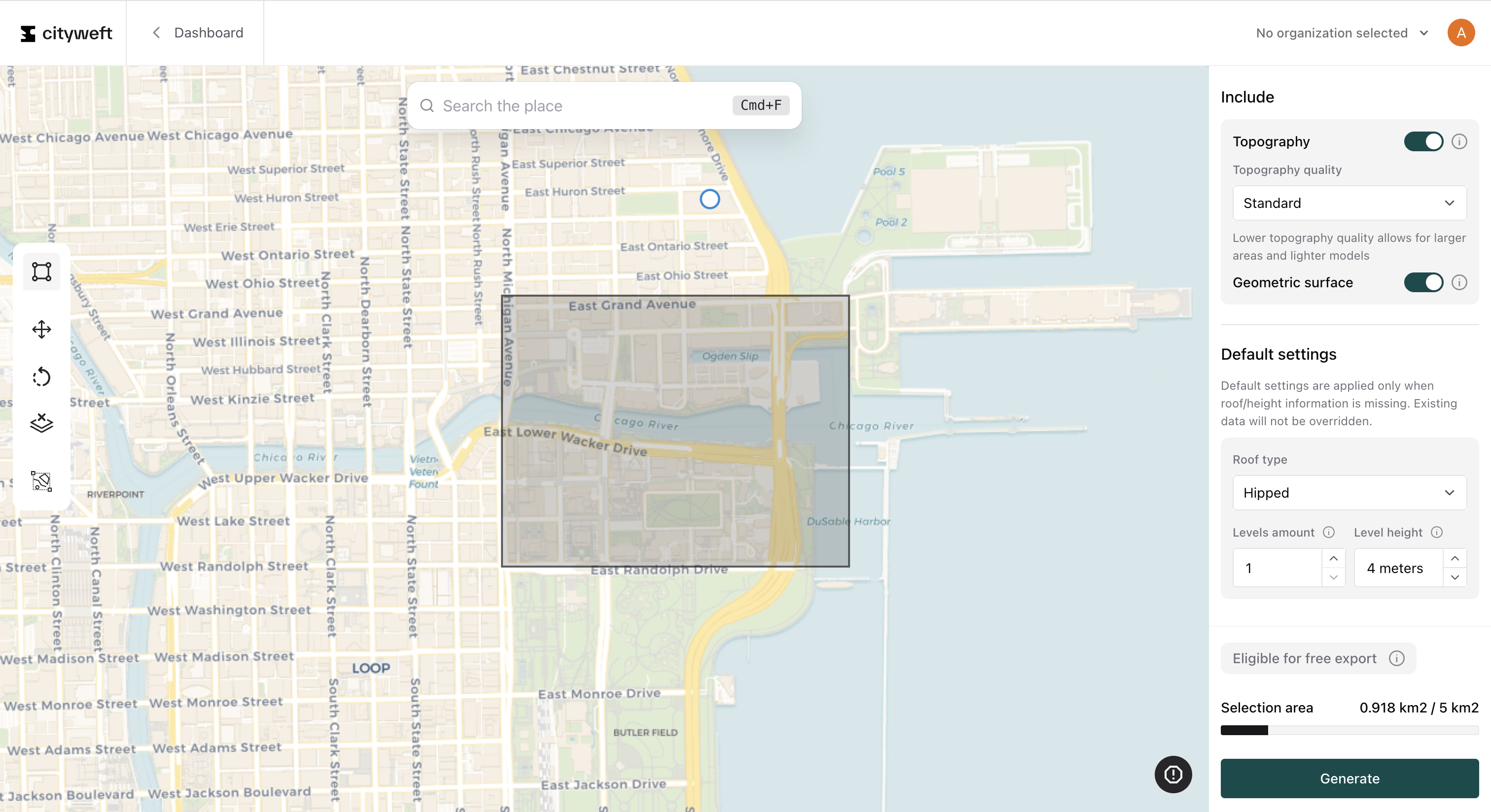
How cityweft Works
Sketch a site anywhere on the map.
Select data layers (buildings, terrain, surfaces, barriers, etc.).
Export directly to your preferred format:
CAD formats: Rhino (.3dm), SketchUp (.skp), Revit (.rvt), Archicad (.pln), AutoCAD (.dwg).
Standard 3D formats: OBJ, FBX.
GIS formats: GeoJSON, CityGML.
Or connect via API to bring data directly into generative or parametric tools like Grasshopper.
Why Choose cityweft Over Other Sources?
✅ Global Coverage – one consistent source for cities worldwide.
✅ CAD-Ready Geometry – clean, editable models (not just rough GIS exports).
✅ Up to LOD2 Building Detail – roof types, heights, and profiles where available.
✅ Custom Scene Shapes – export exactly what you need (not limited to rectangular areas).
✅ API Access – integrate into automated workflows and custom apps.
✅ Rich Data Layers – topography, surfaces, barriers, infrastructure, and metadata.
✅ Trusted Sources – built from 150+ datasets, including government, LiDAR, ML-derived buildings, and global mapping data.
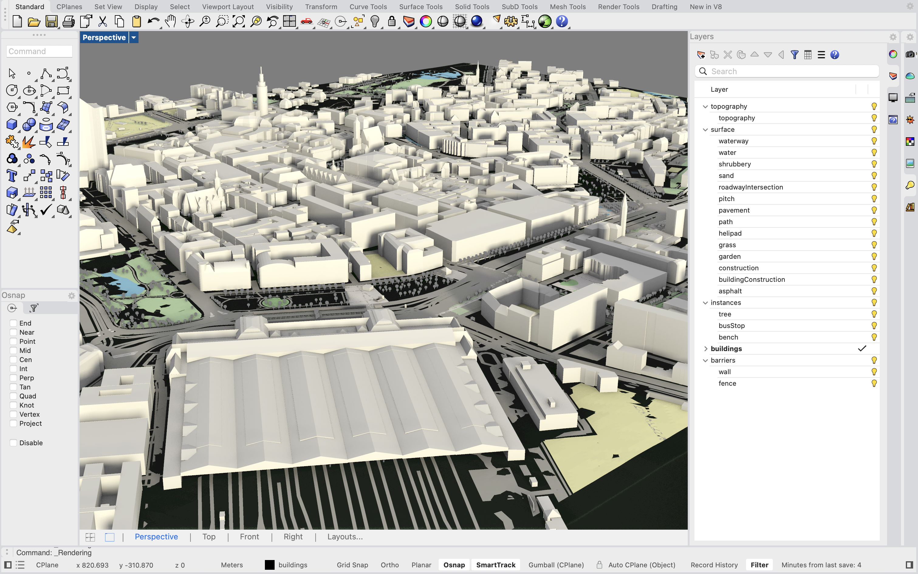
Cityweft model of Leipzig, Germany exported as a 3DM file to Rhino 8.
Use Cases
Design Competitions: Import context quickly into Rhino or Revit to start modeling.
Urban Studies: Compare development massing scenarios at city scale.
Generative Design: Connect the API to Grasshopper and run scripts on global data.
Campus & Masterplanning: Analyze terrain, road networks, and surrounding density.
Visualization & Simulation: Produce context models for rendering or daylight analysis.
How to Get Started with cityweft
Free Access: Export up to 1 km² for free to test the platform.
Professional Plans: Unlock richer datasets, larger exports, and API integrations.
Developers: Explore the REST API for embedding cityweft data directly into your tools.
👉 Start here: Access the cityweft platform
FAQ
Does cityweft provide building height data?
Yes. cityweft integrates accurate building heights from multiple sources, including government registries, LiDAR scans, and machine learning models. Heights are standardized across regions and can be exported directly into CAD software, making them essential for massing studies, solar analysis, and other design workflows.
Can I access 3D city data via an API?
Yes. In addition to CAD-ready exports, cityweft offers a REST API for programmatic access to global 3D city data. This allows developers to integrate models into Grasshopper, generative design tools, or custom applications. Full documentation is available here: cityweft API Docs.
What file formats does cityweft support?
cityweft supports direct exports into professional CAD and BIM tools including Rhino (3DM), Revit (DXF*), SketchUp (SKP*), and more. It also provides industry-standard formats such as OBJ, STL, GLB, and GLTF for broader workflows.
Which regions does cityweft cover?
cityweft provides global coverage, with data sourced from over 150+ providers. This includes government registries, LiDAR scans, satellite imagery, and machine learning–derived buildings. Whether you need models for major metropolitan areas or smaller regional cities, Cityweft delivers consistent data that integrates directly into CAD and BIM tools.
Is cityweft data free to use?
cityweft offers both free and premium data. Some basic datasets - such as footprints and OpenStreetMaps building models - are available at no cost. For more advanced use cases, Cityweft provides premium data products that include standardized 3D geometry, building heights, topography, and infrastructure. These are available as CAD-ready downloads or via the Cityweft API, with various pricing options to fit specific needs.